Full Description
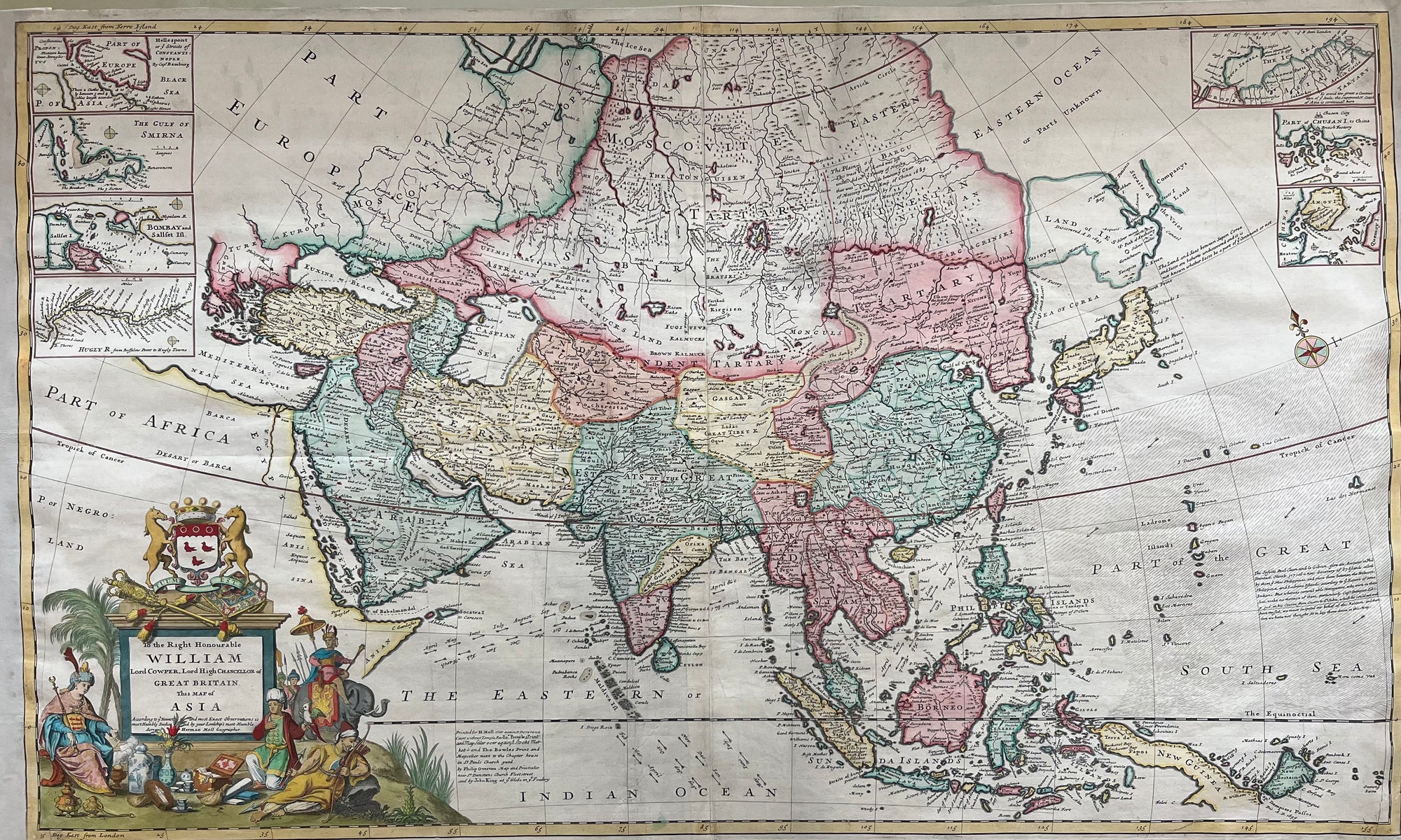
This Herman Moll Asia map 1720 is a large, hand-colored map engraved on two joined sheets around 1720. It was dedicated to William Lord Cowper, Lord High Chancellor of Great Britain. The map was published in London by H. Moll and associates. It captures Asia just before the height of European imperial expansion.
The map features an elaborate cartouche topped by the arms of Lord Cowper. It includes seven detailed vignette maps. These show strategic areas such as the Hellespont, Gulf of Smirna, Bombay and Sallset Islands, and the Hugly River. Some vignettes depict parts north of the Arctic Circle, including Nova Zembla. Others show small areas of the Chinese coast like Chusan Island and Amaoy Island.
Collectors value this Herman Moll Asia map 1720 for its rich colouring and intricate detail. It is also important as a historical record of early 18th-century Asia. Moll’s work reflects British geopolitical and commercial interests at the time. This makes the map a fascinating piece for map enthusiasts and historians alike.
Explore our collection of fine antique maps.
About the Artist: Herman Moll
Herman Moll (c. 1654 – 1732) was a highly influential British cartographer, engraver, and map publisher originally from Germany or the Netherlands (exact birthplace unknown). Moving to London around 1678, Moll began his career engraving maps for others before establishing his own successful publishing business. He produced and published numerous important atlases, maps, and globes, including “Atlas Geographus” (1708–1717) and “The World Described” (1715), renowned for their detailed, decorative cartouches and political messaging supporting British claims worldwide. Moll also created many maps for voyages and exploration accounts, such as those by William Dampier. His maps balance artistic elegance with geographic detail, making them highly prized. Moll was connected with notable figures like Robert Hooke and Jonathan Swift, and his maps influenced British colonial and maritime policies. His work remains a landmark in early 18th-century cartography.
About the Era: 18th Century (1700s)
During the 18th century, mapmaking became more scientific and precise. Improved instruments like the telescope and chronometer helped cartographers increase accuracy, shifting maps from decorative art to factual documents. Copperplate engraving stayed as the main printing method, producing fine lines, while hand-coloring added visual impact. French cartographers, such as the Cassini family, led national surveys with geodetic measurements and triangulation, while Dutch mapmakers like Joan Blaeu enhanced printing and atlas quality, ushering in a golden age of atlases.
Maps began including more information and notes to help users, and ornate decorations mostly gave way to scientific clarity, except for cartouches and borders. National and colonial ambitions guided map production to aid navigation and territorial claims. By the late 18th century, large-scale surveys set modern cartography standards. Today, 18th-century maps mix scientific knowledge with artistry, are prized by collectors, and have influenced later cartographic methods. They offer insights into Enlightenment exploration and geography.