Engraving by Isaak Tirion, circa 1760
€350.00
This authentic antique print, measuring 30 cm × 47.5 cm , created by Isaak Tirion as a fine example of Engraving work from the 18th Century (1700s).
Published by Isaak Tirion, it is preserved in Very Good condition and displays remarkable period craftsmanship.
1 in stock
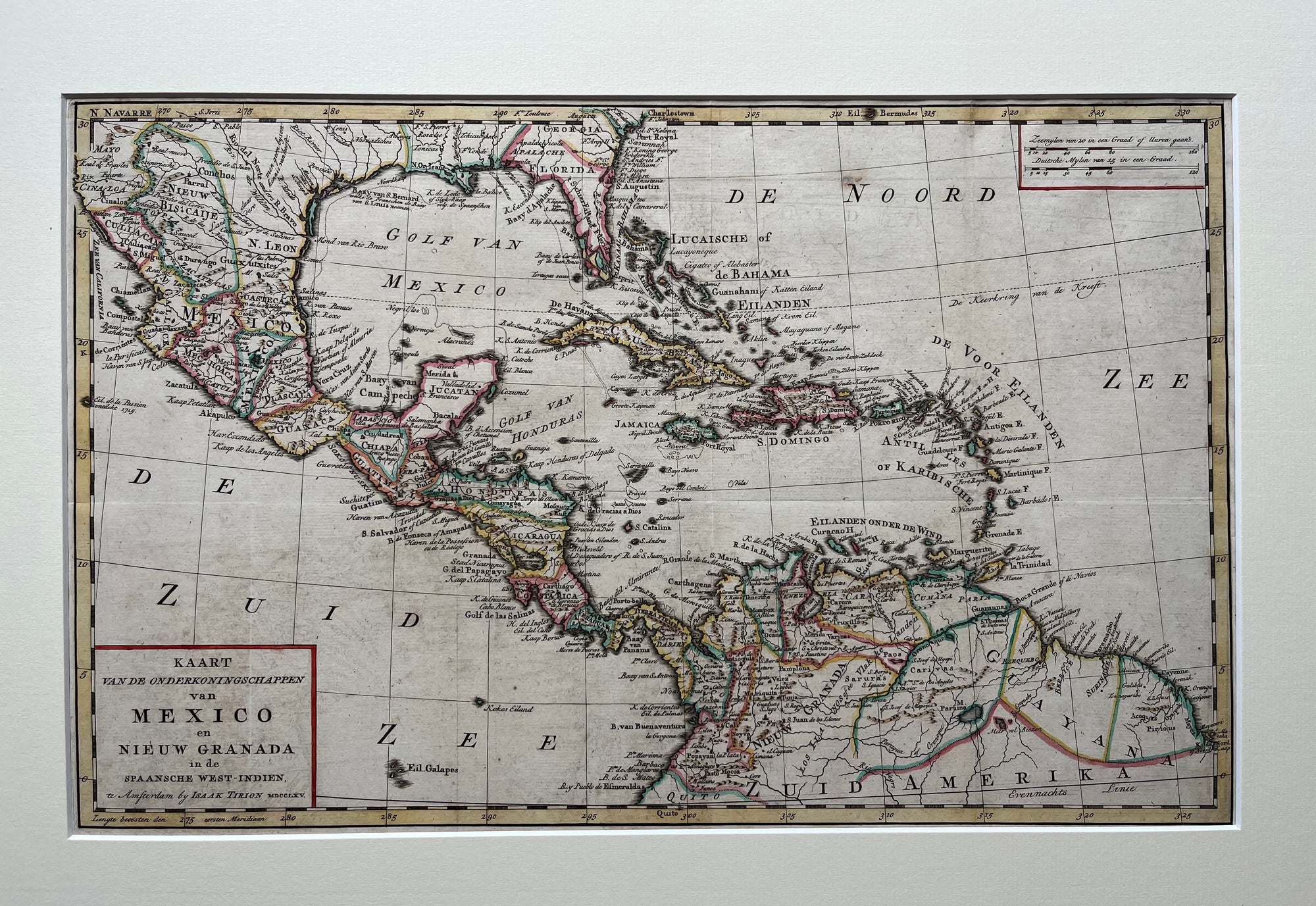
This historical map, titled Kaart van de Onderkoningschappen van Mexico en Nieuw Granada in de Spaansche West-Indien ( Map of the Viceroyalties of Mexico and New Granada in the Spanish West Indies), was made by Isaak Tirion, a notable Dutch cartographer from the 18th century.
The map is in Dutch and highlights Central America. It includes modern countries such as Mexico, Guatemala, Honduras, Nicaragua, Costa Rica, and Panama. It also shows Caribbean islands with their colonial names, for example Jamaica, Cuba, and Hispaniola labeled as St. Domingo. Northern South America appears as well, covering Colombia, Venezuela, and Ecuador, part of the Viceroyalty of New Granada. Furthermore, the southern United States is visible, then part of New Spain.
Major bodies of water feature Dutch names like GOLF VAN MEXICO (Gulf of Mexico), GOLF VAN HONDURAS and ZEE VAN DE VOOR EILANDEN (Caribbean Sea), and the Atlantic Ocean labeled as DE NOORD ZEE and DE ZUID ZEE.
The map displays Spanish colonial regions clearly. Regions such as N. Leon, Guatemala, Yucatan, and Caracas are marked with colored borders. It uses old Dutch cartographic scripts for places like De Haavens van Havana, Cumana, Cartagena, and Curacao. Additionally, decorative title cartouches are framed in red-bordered boxes.
Created around 1760, this map gives a valuable glimpse into the Spanish Empire’s layout in the Americas before independence movements began in the 19th century. The Dutch, including Tirion, played a key role in publishing maps of the New World during this important era.
Isaak Tirion (1705–1765) was a prominent Dutch publisher, mapmaker, and bookseller based in Amsterdam. Born in Utrecht, he gained distinction in the 18th century for publishing numerous atlases, maps, and historical works. Tirion’s maps often built upon earlier cartographers’ work, such as Guillaume Delisle, combining precision with decorative artistry. He published important atlases like the “Nieuwe en Beknopte Hand-atlas” (1744–1769) and maps of the New World that reflected the latest geographical discoveries. His atlases included highly accurate and detailed regional descriptions, such as those of the province of Zeeland. Collectors value Tirion’s work for its beauty, accuracy, and place as one of the last great Dutch mapmakers of the Golden Age, bridging old traditions and new styles in cartography.
During the 18th century, mapmaking became more scientific and precise. Improved instruments like the telescope and chronometer helped cartographers increase accuracy, shifting maps from decorative art to factual documents. Copperplate engraving stayed as the main printing method, producing fine lines, while hand-coloring added visual impact. French cartographers, such as the Cassini family, led national surveys with geodetic measurements and triangulation, while Dutch mapmakers like Joan Blaeu enhanced printing and atlas quality, ushering in a golden age of atlases.
Maps began including more information and notes to help users, and ornate decorations mostly gave way to scientific clarity, except for cartouches and borders. National and colonial ambitions guided map production to aid navigation and territorial claims. By the late 18th century, large-scale surveys set modern cartography standards. Today, 18th-century maps mix scientific knowledge with artistry, are prized by collectors, and have influenced later cartographic methods. They offer insights into Enlightenment exploration and geography.
| Dimensions | 30 × 47.5 cm |
|---|---|
| Artist | |
| Condition | |
| Era | |
| Frame | No Frame |
| Orientation | |
| Publish Date | circa 1760 |
| Published by | Isaak Tirion |
| Technique | Engraving |
Our antique prints are carefully packaged to ensure safe arrival.
Smaller prints are shipped in acid-free, flat protective packaging, while larger works are securely rolled and sent in a sturdy tube to preserve their condition.
Netherlands: €7.50 —
European Union: €15
Outside the EU: On request (contact us for an exact quote)
We offer custom framing for all prints, from classic antique frames to contemporary minimalist styles.
Choose any print from the collection
We discuss frame styles, materials & pricing
The print will be professionally framed and shipped via courier for maximum safety
If you would like your print framed, please contact us, we are happy to advise on styles and options.
Our highest classification. These prints are clean, bright, and exceptionally well-preserved, featuring a strong and crisp image. No notable imperfections.
Prints in this condition show a clean, sharp image. Paper quality or margin size may vary slightly. Minor age-related characteristics, such as small wormholes, light toning, or tiny separations may be present depending on the print date.
No major imperfections. Any minor flaws or historical repairs are fully noted in the product description. Overall a well-preserved and collectible piece.
These prints show noticeable imperfections such as foxing, weaker image strength, or longer separations, but remain collectible. All visible characteristics are clearly described.