Full Description
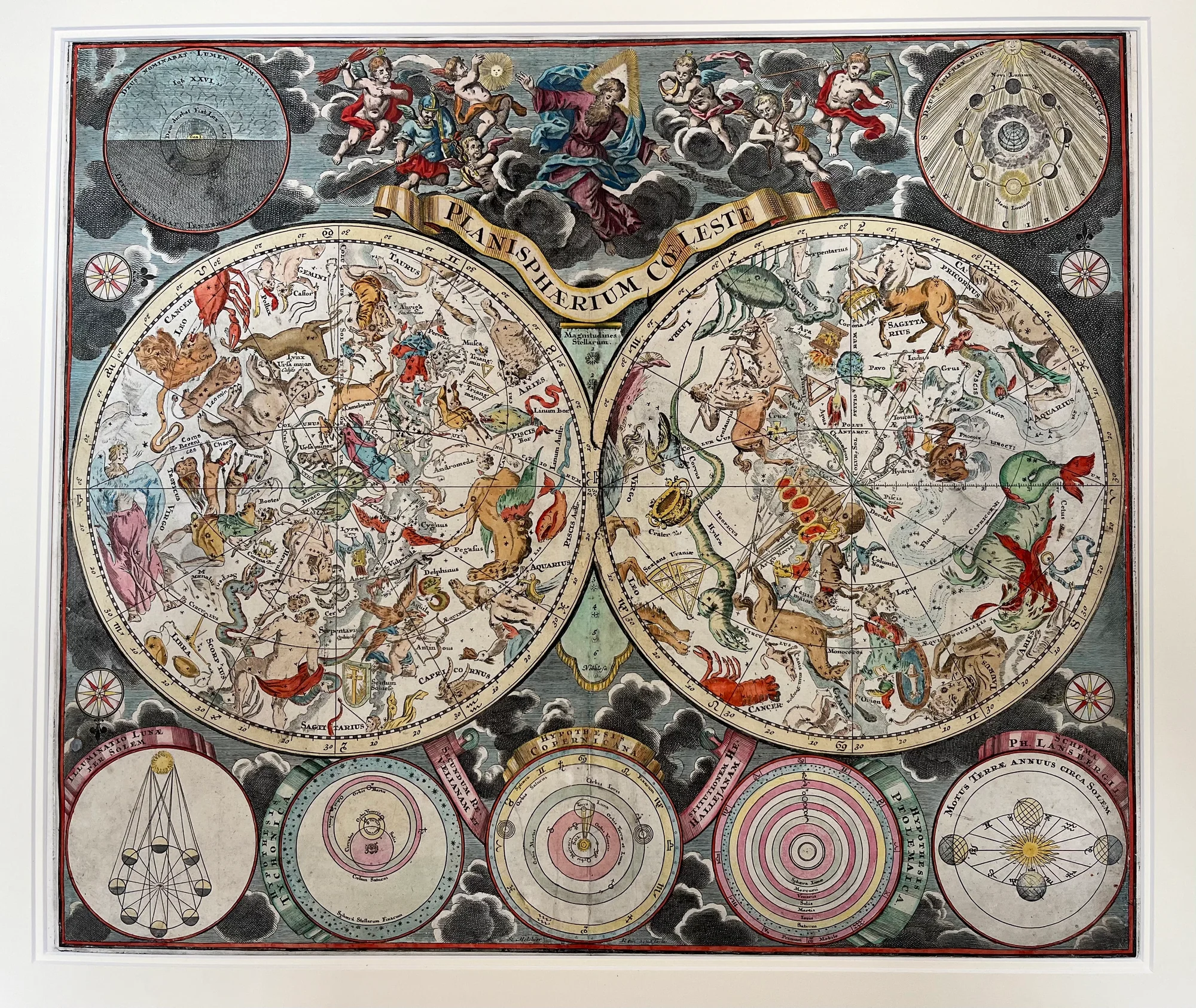
This magnificent Celestial Map by Homann, Planisphaerium Coeleste, was created around 1730 by the renowned German cartographer Johann Baptist Homann. It presents two richly decorated hemispheres illustrating the northern and southern night skies.
Each constellation is vividly hand-colored and adorned with classical mythological figures such as lions, serpents, heroes, and gods. These figures reflect the Baroque era’s vision of the heavens, combining scientific accuracy with artistic grandeur.
Surrounding the celestial spheres are intricate astronomical diagrams depicting planetary orbits, lunar phases, and both Ptolemaic and Copernican models of the cosmos. Celestial deities preside at the top, symbolising divine order and cosmic majesty.
This Celestial Map by Homann was produced as a hand-colored copper engraving. This map measures 50.5 by 58.5 cm and was published by the Homann Heirs in Nuremberg. It is a masterpiece of Enlightenment cartography, marrying knowledge and beauty in equal measure.
Collectors and astronomy enthusiasts prize this work for its historical significance and exquisite craftsmanship.
About the Artist: Johann Baptist Homann
Johann Baptist Homann (1664–1724) was a renowned German geographer, cartographer, and founder of one of the most important map publishing houses in 18th-century Europe. Born in Oberkammlach, Bavaria, he was educated as a Jesuit and initially prepared for an ecclesiastical career but later converted to Protestantism.
Homann moved to Nuremberg, where he began working as a notary and started his cartographic publishing business in 1702. He published his first atlas in 1707 and subsequently became a leading figure in German and European mapmaking. In 1715, he was appointed Imperial Geographer by Emperor Charles VI and made a member of the Prussian Academy of Sciences.
Homann’s maps are noted for their scientific accuracy, artistry, elaborate cartouches, and Baroque style. His major publication, the “Grosser Atlas über die ganze Welt” (Great Atlas of the Whole World), established his reputation. The Homann publishing house continued after his death, influencing mapmaking well into the 19th century.
About the Era: 18th Century (1700s)
During the 18th century, mapmaking became more scientific and precise. Improved instruments like the telescope and chronometer helped cartographers increase accuracy, shifting maps from decorative art to factual documents. Copperplate engraving stayed as the main printing method, producing fine lines, while hand-coloring added visual impact. French cartographers, such as the Cassini family, led national surveys with geodetic measurements and triangulation, while Dutch mapmakers like Joan Blaeu enhanced printing and atlas quality, ushering in a golden age of atlases.
Maps began including more information and notes to help users, and ornate decorations mostly gave way to scientific clarity, except for cartouches and borders. National and colonial ambitions guided map production to aid navigation and territorial claims. By the late 18th century, large-scale surveys set modern cartography standards. Today, 18th-century maps mix scientific knowledge with artistry, are prized by collectors, and have influenced later cartographic methods. They offer insights into Enlightenment exploration and geography.