Full Description
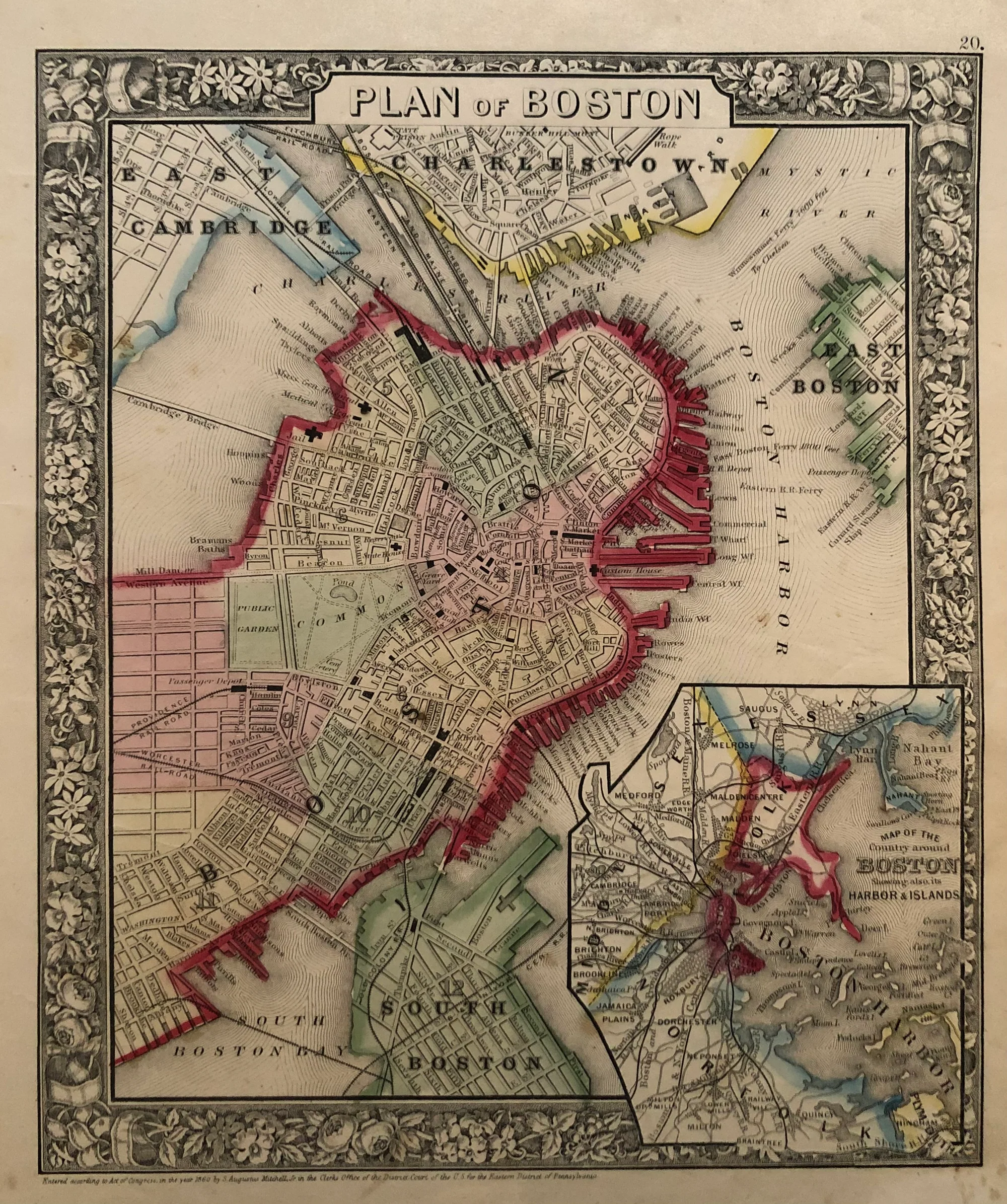
This vintage Boston map, titled ‘Plan of Boston,’ was created by S.A. Mitchell in 1860. The lithographed map shows Boston, Massachusetts, along with East Cambridge, Charlestown, East Boston, and South Boston. It includes an inset map of Boston Harbor and nearby islands, adding valuable geographic detail. The map measures 30.5 by 25.5 cm and is in very good condition. S.A. Mitchell was a well-known 19th-century cartographer whose maps are prized for their accuracy and detail.
This map offers a historic view of Boston and its surroundings during a period of growth and development. Collectors and history enthusiasts appreciate this vintage Boston map for its artistic color and precise rendering. Adding this map to your collection brings a piece of 19th-century American cartographic history. It blends educational value with decorative appeal, making it an excellent choice for map lovers and history buffs.
About the Artist: Samuel Augustus Mitchell
S.A. Mitchell was a leading American cartographer in the 1800s. He created detailed maps and atlases that helped people understand geography across the United States. Mitchell made maps for schools and businesses that guided travelers and learners during America’s growth. Collectors value his maps for their accuracy and historical importance.
About the Era: 19th Century (1800s)
The 19th century marked the era of cartography, as mapmaking became professional, organized, and global. Scientists and surveyors used improved instruments and statistical methods, turning maps into trusted scientific documents with greater precision. Surveying advanced with triangulation, precise tools, and national topographic programs. Printing technology improved, adopting lithography and early color printing to produce clearer, richer maps. New thematic maps used techniques like choropleth, flow lines, and dot density to show data visually. Notably, Charles Minard pioneered multivariate mapping, combining multiple data themes on one map.
Map design reflected industrial and Victorian tastes, balancing detail and readability. Governments supported mapping societies to control territories at home and abroad. Maps became essential for urban planning, empire-building, and scientific research. The 19th century also fostered a global map culture, sharing knowledge internationally. Today, 19th-century maps are prized for their science and artistry. They laid the foundation for modern cartography, data visualization, and geographic information science, and are celebrated by collectors and institutions for their insight into industrial-age geography and culture.